- Stories
- History Articles
- Mercury Bay history series – the recent history of Mercury Bay
Mercury Bay history series – the recent history of Mercury Bay

Geology is our history writ large. It is all around us in the rocks and landforms we see everyday and these can help us decode our past. This article explores the fascinating geology of the Mercury Bay and refers to what geologists call ‘recent’ history. In essence this is the time since the last major Ice Age which ended about 16,000 years ago.
Help us get the word out!
If you like this article, please share it!
Our Real History
There are many excellent photographs of our past landscapes, largely from Whites Aviation taken between about 1920-1988; but the one above from Toby Morcom’s collection tells a great story. It is striking in many ways, with the lack of development and vegetation being the first things to notice. However, it also shows very well the series of curved ridges extending out towards the present coastline both in Whitianga in the foreground and also Cooks Beach in the distance. Many of these are now hard to see due to recent housing developments. However, all those curved lines are previous shorelines that started forming about 4,000 years ago when the sea was actually at its highest point in the last 16,000 years, at least 1-2m higher than now.
While most of New Zealand was not covered in kilometres of thick ice like much of North America during the last major Ice Age, there were still significant effects here. Quite apart from the cooler temperatures that meant that much of Whitianga was largely covered in beech forests, the main change were that much of the world’s water was locked up in ice caps and glaciers. In fact the sea was about 120m lower then and you could walk from Whitianga to Great Barrier Island, the South Island and even Stewart Island without getting your feet wet. The coastline for us in Mercury Bay was about 40km offshore, so a long way to the beach back then! This is actually the normal situation for us as for 90% of the last 1 million years we have been in ice age conditions. In between about 10 major ice ages in that period, each lasting about 100,000 years, were warm ‘interglacial’ periods lasting about 12-15,000 years, the latest of which we are currently enjoying at present.
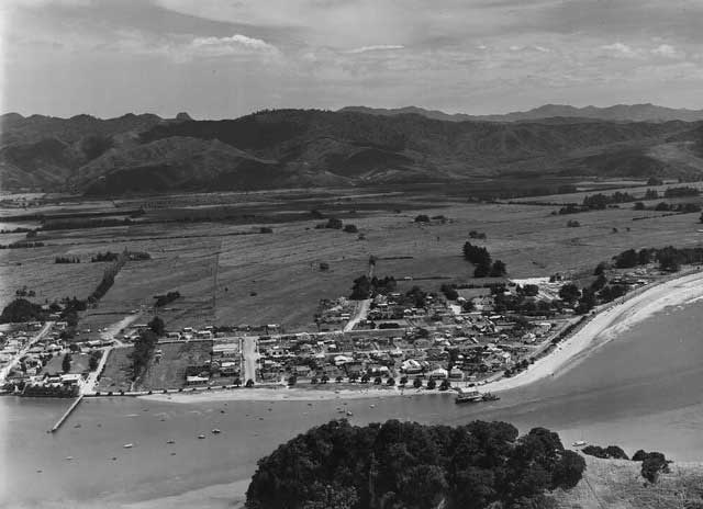
Whites Aviation Photo of Whitianga Showing Arcuate Beach Ridges Extending to Foothills - 1959
Beach Ridges
When the ice fully melted from the last major ice age, starting about 16,000 years ago, the sea rapidly rose back up and actually came almost 3 km further inshore than it is now and left a beach ridge by the airfield about 2-4m above our present beach. As the sea gradually fell it left behind a series of beach ridges every time it paused or reversed its movement every few decades or centuries. These ridges are the curved lines in Toby’s photograph (at the top of the article) and they get progressively younger as you move towards the coast.
There are about 30 of these ridges in Mercury Bay and about 15 still preserved in Cooks Beach. They give us the big picture and tell us that the sea has been progressively retreating at about half a metre a year over the last 4,000 years or so. When the ‘Little Ice Age’ started (AD 1300) the sea would be about half a metre lower than it is now. Since this ended in about 1850 it has now been gradually coming back in and is causing some beach erosion.
Importantly however, these ridges also tell us that the sea oscillates back and forth on a time scale of decades or centuries. When it moves inwards the beach is eroded and eventually a new ridge is thrown up during a big storm event and then the sea moves outwards once again. It seems likely that the sea will continue to move outward for the next few hundreds or maybe thousands of years but in between it will come back from time to time and grab some of the beach until the next major ice age finally moves it 40 km offshore for another 100,000 years.
Unfortunately we have built Whitianga, Cooks Beach, Tairua and many other settlements on this unstable and newly acquired beach ridge land. Whether that was wise only time will tell but we will have plenty of time to adapt if necessary.
Shoreline Terraces
Another legacy of past higher sea levels can be clearly seen at Cathedral Cove, Tairua and elsewhere if you know where to look. Each time the sea comes inland and stays there for a long time it often forms a flat beach terrace as it erodes the rocky foreshore which it then leaves behind when it moves offshore. Cathedral Cove shows this particularly well.

Cathedral Cove Terraces
In the photo above you can see the current high water terrace that is now being cut in the rocks by the present sea level high tide conditions. To the right is the 2m high terrace formed when the sea was at its highest point about ,4000 years ago, around the time when the oldest terraces were formed at Whitianga airport. Further to the right is yet another step-like terrace, about 4m high, that was actually formed at the warmest period of the last interglacial between the last two major ice ages, about 120,000 years ago! So the overall big trend is that sea levels are getting lower as the world continues its cooling trend established some 60 million years ago (still recent history for a geologist!).
These three terraces can also be seen at Tairua. The photo below was taken in the rest area and playground at the southern end of town by the SH25 bridge. The modern harbour flats terrace is the present shoreline at high tide and the 0.5m terrace is what was formed about 4,000 years ago. Much of the town is built on this terrace, just like Whitianga. In the background you can see the 4.5m terrace by the town hall which was formed between the last two major ice ages as at Cathedral Cove.
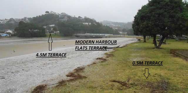
Tairua Terraces
So as can be seen from our local rocks and landscapes, we are just a blip in a very big and very changeable history. It’s a complex story but fortunately the pages of history left on our shorelines can help us read it. Where the sea will go in the future nobody really knows and there is no way we can alter or control it. We just borrow land by the sea from Mother Nature and Father Time – it belongs to them. Undeniably we humans like to live by the coast. It’s a gamble we take; sometimes we win, sometimes we lose.
Article Contributor
This article was provided by Alastair Brickell, Local Geologist and Committee Member Mercury Bay Historical Society (2020).
Related Links
Mercury Bay Historical SocietyMore History Articles


Social activities of yesteryear

Mercury Bay History Series – Establishment of the Mercury Bay Museum

Mercury Bay History Series – Coromandel Peninsula Geology

Mercury Bay History Series – Box Net Fishing

-
{{#owner}}
-
{{#url}}
{{#avatarSrc}}
{{name}} {{/url}} {{^url}} {{#avatar}} {{& avatar}} {{/avatar}} {{name}} {{/url}} - {{/owner}} {{#created}}
- {{created}} {{/created}}